
Salmon River Trestle Pool Project in Oswego County, NY
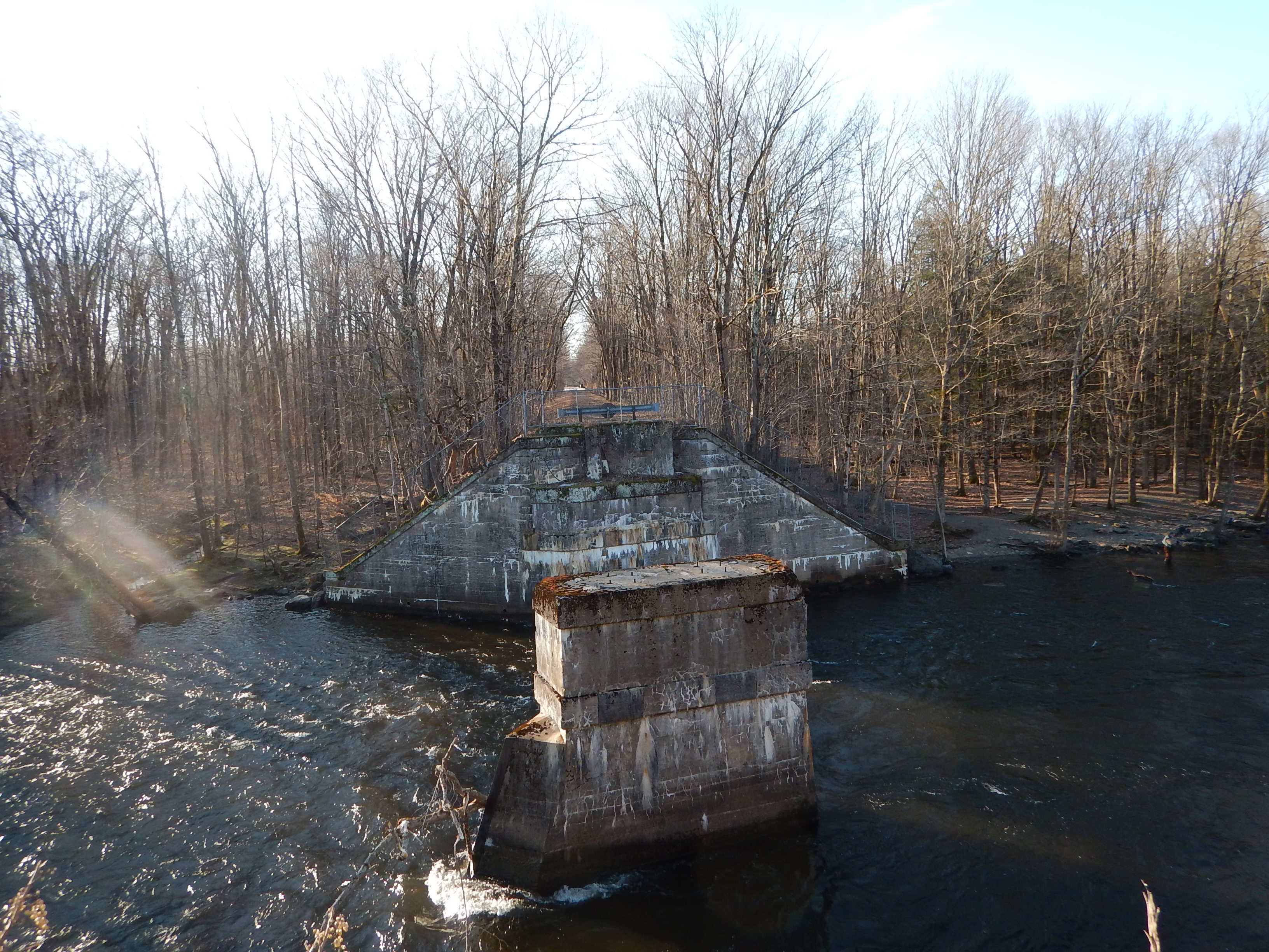
Pre Construction project site of left abutment
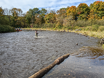
Toewood installation upstream of project site
The Lake Ontario Committee (LOC) agencies are undertaking stocking and habitat restoration projects to re-establish native Atlantic salmon in Lake Ontario, particularly in key locations like the Salmon River. This project site, is an area where degraded riparian and stream conditions are contributing to unsuitable habitats for Atlantic salmon spawning and rearing. Historic hydroelectric generation operations have created an unstable channel in the Lower Salmon River, which interrupted natural sediment transport, degraded instream habitat, and induced excessive streambank erosion.
The Trestle Pool restoration site, which consisted of an abandoned railroad trestle with associated abutments, backed up water during high flow events, inhibited sediment transport, increased upstream sedimentation, was disconnected from the floodplain, and induced streambank erosion in the downstream reaches. This project removed the abandoned railroad central pier and left abutment to provide hydrologic reconnection to the floodplain by reconnecting approximately 150 linear feet (including 0.2 acres) of floodplain to the river and restoring habitat heterogeneity, while reducing in-stream and bank erosion, through installation of in-stream structures and toe-wood bank stabilization structures to 600 linear feet of streambank. Restoration of natural erosion and deposition processes from this project will improve Salmon River habitats for production of Atlantic salmon and other native species. Project partners include New York State Department of Environmental Conservation, USFWS New York Field Office (USFWS NYFO), and Finger Lakes Lake Ontario Watershed Protection Association (FLLOWPA), and National Oceanic Atmospheric Administration Restoration Center (NOAA).
Plan level engineering and design have been completed by USFWS NYFO staff along with feasibility work as a part of the Plan. In addition to the removal of the railroad trestle and left abutment, a grade control structure will be installed immediately downstream of the trestle span and a J-hook vane structure will be installed just upstream of the existing span. The toe wood structures, J-hook vane structures, and grade control structures are all well-established restoration techniques for stream reaches that are slightly-to-moderately meandering, have a moderate to high gradient, and are incising and causing excessive streambank erosion. All streambank and floodplain areas were planted with live stakes, seeded, and mulched once construction is complete. Additional trail construction and stabilization will occur to improve angler access.
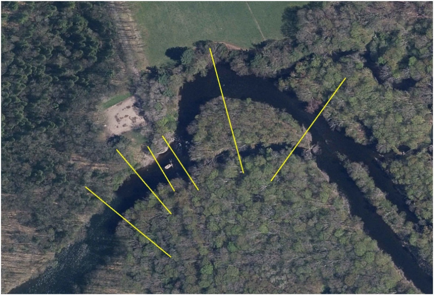
Locations of monumented cross sections on the Salmon River
In 2023, USFWS NYFO staff visited the project site and survey/stake out the project for final design and as-built surveys and substrate and flow rate were assessed to ensure the project was constructed to design. Additionally, USFWS NYFO and NYSDEC staff has been collecting stage-discharge information at the project site to develop a rating curve and demonstrate floodplain reconnection with project implementation.
The currently planned timeline includes construction during summer 2023 and will be complete in summer 2024. All New York State and USACE permits for the proposed work are in place, and Federal NEPA compliance was completed. To avoid potential impacts to young-of-year salmonids and reduce potential angler conflicts, work would be completed between June 15 and August 31, 2024.
The Salmon River Trestle Pool project, implemented by NYSDEC, USFWS NYFO, and FLLOWPA will generate environmental data and information, including pre-construction survey data to support design and document existing channel slopes, channel width, flow rate, and land elevations including cross sections of structures, channels, wetlands and floodplains. The survey will include a longitudinal profile of the bed and water surface at the j-hook, grade control structure, and trestle pool/abutment locations including the structures; channel cross-sections referenced to bankfull elevation will be collected at six monumented cross sections. As-built surveys and topographic data will include post-restoration channel width, channel depth, land elevations, and the floodplain surface. Predicted water levels at the project site based on the discharge at the USGS gage in Pineville, NY (04250200), discharge at the Lighthouse Hill Reservoir, and predicted water levels at the project site will be collected and updated as available. Additionally, photo monitoring station photographs of the entire project area pre-, during, and post-construction at georeferenced locations.
Pre-construction land elevation survey data and as-built surveys and topographic data, water discharge and water levels data, and photographic data was collected by NYSDEC, USFWS NYFO and/or contractors according to the procedures described in the Salmon River Trestle Pool Project Quality Assurance Project Plan. The data will be stored internally by USFWS NYFO and NYSDEC as well as on the GLFC website. The data will be available to the public either through the aforementioned website or upon request within 60 days of data collection and validation, starting during the fall of 2023, through the summer 2026. Contact Jeff Tyson for more information or to make a data request. All future sub-awardees not identified in this plan will have as a condition of their contract acceptance of this data sharing plan. Any additional data sharing stipulations for future sub-awardees may be outlined at that time and described in their contract.