
Inner Saginaw Bay Reef Restoration Project
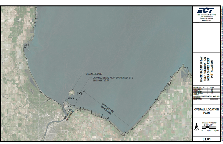
Figure 1. Location of proposed reef relative to Channel Island in Saginaw Bay of Lake Huron, Bay County, MI. Image: ECT, Inc.
Historically, reef habitats in Saginaw Bay have been degraded by impacts from physical destruction, degradation from shoreline development, sedimentation, chemical contamination, and aquatic invasive species (e.g. dreissenid mussels, rusty crayfish). The Lake Huron Committee (LHC), along with federal partners, are in the process of rehabilitating self-sustaining stocks of both lake trout and cisco in Lake Huron, with Saginaw Bay being the site for initial rehabilitation stocking for cisco. The proposed project addresses a LHC priority to implement actions to address reef degradation to enhance production for multiple species of common concern across Lake Huron, including lake trout, lake whitefish, walleye, and cisco in the Saginaw Bay, Michigan region. This reef restoration project builds off of a pre-construction assessment project, funded by the U.S. Fish & Wildlife Service’s (USFWS) Great Lakes Fish and Wildlife Restoration Act, which indicated that conditions in inner Saginaw Bay are suitable for reef restoration and will use lessons learned from a nearby recent reef restoration project, the 2-acre Coreyon Reef. More information about other habitat and resilience projects in Saginaw Bay can be found at Michigan Sea Grant's Restoring Fish Spawning Habitat page.
This proposed project will establish needed spawning habitat in inner Saginaw Bay, using natural materials and techniques similar to the Coreyon Reef restoration, in proximity to appropriate thermal spawning conditions and nursery environments (Figure 1). In addition to enhancing production from important fish species that support fisheries, this project has the potential to be conducted in concert with other shoreline infrastructure work to reduce coastal flooding and erosion, reduce the frequency of navigational dredging, increase recreational access, and increase coastal resilience to climate change. The project will ultimately provide recreational/commercial/tribal fishery benefits and move the LHC closer to the achievement of its fish community objectives, particularly through the rehabilitation of lake trout and cisco populations and contribute to diversifying walleye and lake whitefish production. Project partners include the Great Lakes Fishery Commission (GLFC), Michigan Department of Natural Resources (MDNR) and the Michigan Department of Environment, Great Lakes, and Energy (EGLE) and Michigan Sea Grant.
A feasibility study was completed by MDNR and Environmental Consulting & Technology (ECT Inc.) in February 2022 through a National Fish and Wildlife Foundation (NFWF) funding award to MDNR. The study includes shoreline sediment transport modeling utilizing existing hydrodynamic, wind/wave, and sediment deposition models, as well as extensive side-scan sonar and bathymetric mapping, with the intent to develop a range of conceptual alternatives for consideration for use in the final design and site selection. The initial sites of interest were near Channel Island and near the Kawkawlin River Mouth.
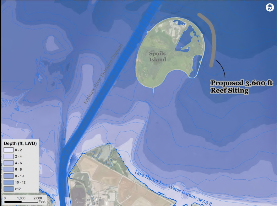
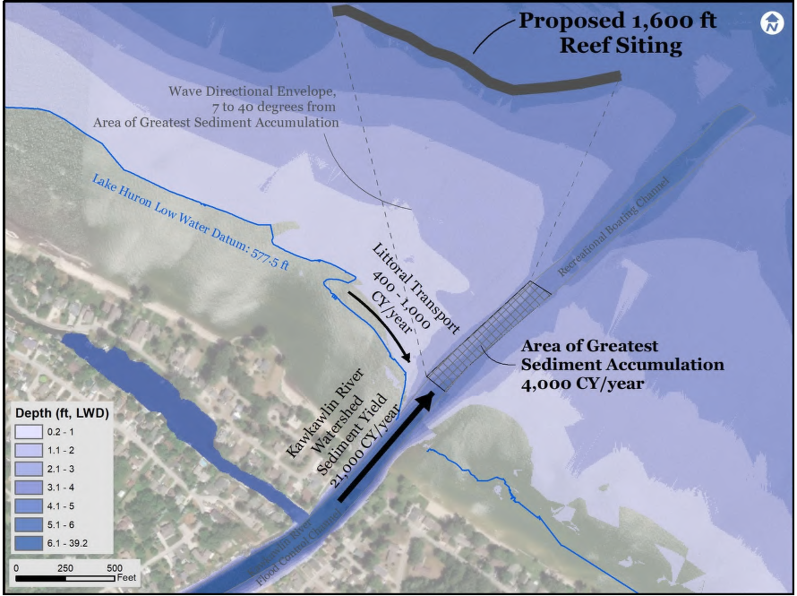
Figure 2. Inner Saginaw Bay Reef Restoration Project potential locations – Bay County, MI In 2022, The GLFC received funding through a NOAA Regional Partnership to advance additional feasibility, engineering/design, and construction studies for options identified through the feasibility study.
A stakeholder scoping workshop was held in 2023 to gather input from local stakeholders. Based on the input gathered from the workshop, the project partners continued to refine the feasibility information for the Channel Island and Kawkawlin River restoration sites. Additional feasibility work includes sediment contaminant sampling at areas of interest near the Channel Island site, refinement of hydrodynamic and sediment transport models at the Kawkawlin River site, as well as pre-restoration fish community and spawning usage at each site, beginning in early 2024. See below for sediment and biological sampling Quality Assurance Project Plans and various feasibility study results.
After considering feedback from local stakeholders and the results of the additional feasibility work for potential sites, the project partners decided to not pursue the Kawkawlin River site and are moving forward with construction plans at the Channel Island site. Further project team meetings resulted in selection of Site D (Figure 3) for construction of an ~2.5-acre reef, as dictated by various design criteria (e.g. size, height, underlying substrate type and contaminants) (43.667883 N, -83.802528 W) for the Channel Island Reef.
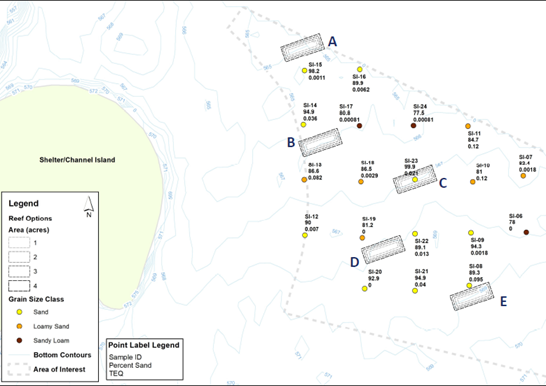
Figure 3. Five location options (A-E) for potential placement of the reef within the Shelter/Channel Island site. Site D was selected as the site with optimal placement meeting design criteria.
The project team has received confirmation from the US Coast Guard that the location and design criteria of the reef at the proposed site will not present any interference to navigation. Final design plans and specifications have been completed and can be found below, and the project is currently in the permitting stage. Construction for the Channel Island reef will start in August and be completed in September 2025, with post-construction monitoring planned in subsequent years.
Data for the project will be collected by MDNR and contractors in accordance with the procedures described in the Quality Assurance Project Plans. As-built surveys (e.g., reef placement, thickness, height, substrate characteristics) and fish community response surveys will be conducted once construction is complete. Much of the pre-construction environment was assessed as part of the initial feasibility and provided pre-site characterizations for comparison to post-construction environmental conditions however, additional assessments are ongoing as detailed below in the QAPPs and Project Products section. In addition, MDNR currently has multiple assessment projects in the project location that will help inform project outcomes and will add various fisheries surveys to inform both the design phase of the project as well as post-restoration response. The data will be stored internally at MDNR and Purdue University, as well as on this GLFC website or upon request within two years of project completion. Contact Jeff Tyson for more information or to make a data request. All future sub-awardees not identified in this plan will have acceptance as a condition of their contract of this data sharing plan. Any additional data sharing stipulations for future sub-awardees may be outlined at that time and described in their contract.